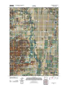
2011 Map of Greenberry
USGS Topo · Published 2011About this map
Muddy Creek meanders north through this Benton County landscape, defining a wide agricultural basin dotted with small settlements and family landing strips. The map documents several concentrated nodes of local history, including Greenberry, Booneville, and Buchanan, which anchor the surrounding farmsteads. To the west, the terrain rises toward Mill Hill and Maple Knoll, while the eastern flats are characterized by a series of water bodies such as McBee Lake and Whitaker Lake. Genealogists will find significant value in the documentation of five distinct burial grounds, including the Armstrong Cemetery in the north and the cluster of Winkle Cemetery, Butte Cemetery, and Irwin Cemetery near the prominent Winkle Butte. This modern survey also highlights the regional aviation infrastructure, noting Venell Airfield and the Coca-Cola Airport alongside larger municipal facilities.
Find a feature on this map
63 named features on this map. Tap any name to fly to it.
Don’t see what you’re looking for? This feature index may not catch every label — zoom into the map to look around manually.
Map Details
Editions of this 2011 Greenberry Map
This is the sole edition of this map. No revisions or reprints were ever made.
Other maps of this area

1909 · Harrisburg
USGS Topo · 1:31,680

1911 · Monroe
USGS Topo · 1:31,680

1911 · Inavale
USGS Topo · 1:31,680

1912 · Halsey
USGS Topo · 1:62,500

1913 · Philomath
USGS Topo · 1:31,680

1913 · Oakville
USGS Topo · 1:31,680

1916 · Albany
USGS Topo · 1:62,500

1921 · Corvallis
USGS Topo · 1:62,500

1922 · Monroe
USGS Topo · 1:62,500

1939 · Monroe
USGS Topo · 1:62,500