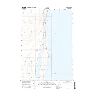
2014 Map of Greenbush
USGS Topo · Published 2014About this map
Greenbush occupies a narrow strip of land between the expansive waters of Lake Huron and the inland shore of Cedar Lake, forming a linear residential and recreational corridor along the Michigan coast. The 2014 landscape is defined by its proximity to the water, where S Huron Rd and Cedar Lake Rd serve as the primary north-south arteries connecting the community. This specific geography creates a distinct settlement pattern where development is hemmed in by the lake systems, transitioning quickly from shoreline homes to the more rural, gridded agricultural land to the west near S McGregor Rd and S Poor Farm Rd. Further south, the map documents the boundary where Alcona Co Iosco Co meet, near the southern extent of the lake and the winding path of Phelan Cr. Local infrastructure is represented through a dense network of residential streets like Sunrise Dr and Woodland Dr that cluster near the Huron beaches.
Find a feature on this map
49 named features on this map. Tap any name to fly to it.
Don’t see what you’re looking for? This feature index may not catch every label — zoom into the map to look around manually.
Map Details
Editions of this 2014 Greenbush Map
This is the sole edition of this map. No revisions or reprints were ever made.
Other maps of this area

1954 · Tawas City
USGS Topo · 1:250,000

1958 · Tawas City
USGS Topo · 1:250,000

1959 · East Tawas
USGS Topo · 1:62,500

1959 · Harrisville
USGS Topo · 1:62,500

1983 · Hubbard Lake
USGS Topo · 1:100,000

1984 · Tawas City
USGS Topo · 1:100,000
1989 · Harrisville
USGS Topo · 1:24,000

1989 · Mikado
USGS Topo · 1:24,000
1989 · Lincoln
USGS Topo · 1:24,000
1989 · Greenbush
USGS Topo · 1:24,000