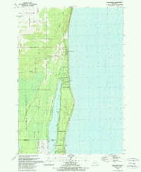
1989 Map of Greenbush
USGS Topo · Published 1989About this map
Greenbush and the adjacent shoreline of Lake Huron define this late 20th-century landscape on the border of Alcona and Iosco Counties. The settlement pattern is largely shaped by the narrow strip of land between the great lake and Cedar Lake, where a concentration of development includes the Post Office and various public access points. To the west, the topography transitions into the protected timberlands of the Au Sable State Forest, characterized by vast swampy sections and small drainage ways like Van Etten Creek. Evidence of local industry and recreation is visible through several Gravel Pits and a Golf Course located near the northern boundary. The map provides a detailed look at the rural road network, featuring family-named routes such as McGregor Road, Ridley Road, and Dellar Road that connected these coastal communities before further modern expansion.
Find a feature on this map
30 named features on this map. Tap any name to fly to it.
Don’t see what you’re looking for? This feature index may not catch every label — zoom into the map to look around manually.
Map Details
Editions of this 1989 Greenbush Map
This is the sole edition of this map. No revisions or reprints were ever made.
Other maps of this area

1954 · Tawas City
USGS Topo · 1:250,000

1958 · Tawas City
USGS Topo · 1:250,000

1959 · East Tawas
USGS Topo · 1:62,500

1959 · Harrisville
USGS Topo · 1:62,500

1983 · Hubbard Lake
USGS Topo · 1:100,000

1984 · Tawas City
USGS Topo · 1:100,000
1989 · Harrisville
USGS Topo · 1:24,000

1989 · Mikado
USGS Topo · 1:24,000
1989 · Lincoln
USGS Topo · 1:24,000
1989 · Foote Site Village
USGS Topo · 1:24,000