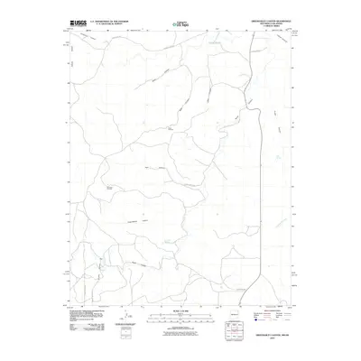
2010 Map of Greendailey Canyon
USGS Topo · Published 2010About this map
Pinon Ridge defines the western edge of this remote high-plains landscape in the Oklahoma panhandle, where a network of deeply incised drainages provides the primary topographic character. Life and industry in this arid region center on critical water resources such as Escondido Springs and Chet Springs, along with vital ranching infrastructure like the Pinon Windmill and Morledge Windmill. The map reveals a complex system of canyons, including Greendailey Canyon and Huff Canyon, that channel seasonal runoff toward Tesesquite Creek. These natural corridors have historically dictated the placement of roads, as seen with Canyon Road and various county routes like County Hwy B-061, which follow the contours of the land rather than a strict cardinal grid. The reliance on scattered springs and windmills underscore the challenges of settlement in this part of Cimarron County.
Find a feature on this map
25 named features on this map. Tap any name to fly to it.
Don’t see what you’re looking for? This feature index may not catch every label — zoom into the map to look around manually.
Map Details
Editions of this 2010 Greendailey Canyon Map
This is the sole edition of this map. No revisions or reprints were ever made.
Other maps of this area

1954 · Dalhart
USGS Topo · 1:250,000

1958 · Dalhart
USGS Topo · 1:250,000

1962 · Dalhart
USGS Topo · 1:250,000

1968 · Kenton
USGS Topo · 1:24,000

1969 · Wheeless
USGS Topo · 1:24,000
1969 · Kenton SW
USGS Topo · 1:24,000

1972 · Seneca
USGS Topo · 1:24,000
1972 · Wedding Cake Butte
USGS Topo · 1:24,000
1972 · Goodson School
USGS Topo · 1:24,000

1972 · Atencio
USGS Topo · 1:24,000