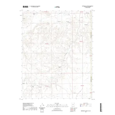
2020 Map of Greendailey Canyon
USGS Topo · Published 2020About this map
The high plains along the border of Oklahoma and New Mexico are defined by a network of drainage systems, including Greendailey Canyon and Huff Canyon. This 2020 landscape in Cimarron County remains sparsely settled, with the small location of Atencio and scattered ranches linked by rural routes like El Valle Escondido Rd and Sayre Rd. The terrain is characterized by prominent ridges such as Piñon Ridge and deep incisions from seasonal watercourses like Carrizozo Creek and Tesesquite Creek. These waterways and springs, including Escondido Springs and Chet Springs, have historically dictated land use and travel patterns in this arid region where the two states meet. The map also shows numerous side canyons such as Black Canyon, West Canyon, and East Canyon branching off the primary drainage basins.
Find a feature on this map
36 named features on this map. Tap any name to fly to it.
Don’t see what you’re looking for? This feature index may not catch every label — zoom into the map to look around manually.
Map Details
Editions of this 2020 Greendailey Canyon Map
This is the sole edition of this map. No revisions or reprints were ever made.
Other maps of this area

1954 · Dalhart
USGS Topo · 1:250,000

1958 · Dalhart
USGS Topo · 1:250,000

1962 · Dalhart
USGS Topo · 1:250,000

1968 · Kenton
USGS Topo · 1:24,000

1969 · Wheeless
USGS Topo · 1:24,000
1969 · Kenton SW
USGS Topo · 1:24,000

1972 · Seneca
USGS Topo · 1:24,000
1972 · Wedding Cake Butte
USGS Topo · 1:24,000
1972 · Goodson School
USGS Topo · 1:24,000

1972 · Atencio
USGS Topo · 1:24,000