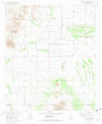
1981 Map of Greene Reservoir
USGS Topo · Published 1982About this map
Arid drainage patterns and agricultural infrastructure define the landscape south of the Sawtooth Mountains during the early 1980s. The region is shaped by the Greene Reservoir and the Greene Reservoir Dam (Site), highlighting a period of significant water management in the Aguirre Valley. Traces of local habitation and industry appear at the settlement of Laguna and scattered throughout the valley via a network of rural routes like Sunland Gin Road and Curtis Road.
Find a feature on this map
25 named features on this map. Tap any name to fly to it.
Don’t see what you’re looking for? This feature index may not catch every label — zoom into the map to look around manually.
Map Details
Editions of this 1981 Greene Reservoir Map
2 editions found
Other maps of this area

1934 · Silver Bell
USGS Topo · 1:125,000

1942 · Silver Reef Mountains
USGS Topo · 1:62,500

1947 · Eloy
USGS Topo · 1:62,500

1948 · Eloy
USGS Topo · 1:62,500

1956 · Tucson
USGS Topo · 1:250,000

1958 · Tucson
USGS Topo · 1:250,000

1959 · Tucson
USGS Topo · 1:250,000

1959 · Vaca Hills
USGS Topo · 1:62,500

1962 · Tucson
USGS Topo · 1:250,000
1963 · Santa Rosa Mountains
USGS Topo · 1:62,500