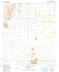
1981 Map of Greene Reservoir
USGS Topo · Published 1993About this map
Greene Reservoir and the extensive water management infrastructure of the Aguirre Valley dominate this arid landscape during the late 1970s and early 1980s. The map illustrates a complex network of desert irrigation, featuring the Greene Canal, Greene Wash, and the designated Greene Reservoir Dam (Site). While the valley floor is organized by industrial farming routes like Sunland Gin Road and Overfield Road, the periphery is defined by the sharp elevations of the Sawtooth Mountains and the West Silver Bell Mountains. Notable landmarks such as Indian Head, Wildcat Peak, and Gold Peak provide vertical contrast to the flat basin. Scattered features including a Landing Strip, the settlement of Laguna, and various borrow pits and prospects reflect the region's mid-century utility and extraction history.
Find a feature on this map
23 named features on this map. Tap any name to fly to it.
Don’t see what you’re looking for? This feature index may not catch every label — zoom into the map to look around manually.
Map Details
Editions of this 1981 Greene Reservoir Map
2 editions found
Other maps of this area

1934 · Silver Bell
USGS Topo · 1:125,000

1942 · Silver Reef Mountains
USGS Topo · 1:62,500

1947 · Eloy
USGS Topo · 1:62,500

1948 · Eloy
USGS Topo · 1:62,500

1956 · Tucson
USGS Topo · 1:250,000

1958 · Tucson
USGS Topo · 1:250,000

1959 · Tucson
USGS Topo · 1:250,000

1959 · Vaca Hills
USGS Topo · 1:62,500

1962 · Tucson
USGS Topo · 1:250,000
1963 · Santa Rosa Mountains
USGS Topo · 1:62,500