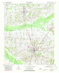
1954 Map of Greenfield
USGS Topo · Published 1981About this map
The agricultural landscape of Weakley and Gibson Counties is defined by the wetlands of the Middle Fork Obion River and the South Fork Obion River. Settlement patterns are anchored by the rail-oriented towns of Greenfield and Sharon, which sit along the Illinois Central Gulf railroad line. The map reveals a dense network of rural community landmarks, including numerous family-named burial grounds like Hornbeak Cem and Brock Cem, alongside local congregations such as Bethel Ch and Bethlehem Ch. Extensive drainage projects are evident through features like Lipscomb Ditch and Wing Ditch, reflecting the mid-century efforts to manage the river bottomlands for cultivation. The inclusion of smaller locales such as Beech Grove and Kimery provides a look at the dispersed rural hamlets that characterized West Tennessee during this era.
Find a feature on this map
35 named features on this map. Tap any name to fly to it.
Don’t see what you’re looking for? This feature index may not catch every label — zoom into the map to look around manually.
Map Details
Editions of this 1954 Greenfield Map
3 editions found
Other maps of this area

1950 · Martin
USGS Topo · 1:24,000

1952 · Dresden
USGS Topo · 1:24,000

1953 · Dyer
USGS Topo · 1:24,000

1954 · Rutherford
USGS Topo · 1:24,000

1954 · Greenfield
USGS Topo · 1:24,000

1954 · Bradford
USGS Topo · 1:24,000

1956 · Gardner
USGS Topo · 1:24,000

1956 · Dyersburg
USGS Topo · 1:250,000

1966 · Trezevant West
USGS Topo · 1:24,000

1967 · Pillowville
USGS Topo · 1:24,000