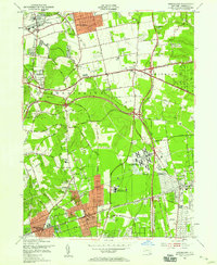
1954 Map of Greenlawn
USGS Topo · Published 1958About this map
Pilgrim State Hospital dominates the southeastern landscape of this mid-century Long Island survey, appearing as a massive institutional complex with its own sewage disposal and power infrastructure. The region is defined by a rapidly expanding suburban network where traditional farmland and wooded elevations like the Huntington Hills are being bisected by major thoroughfares, including the Northern State Parkway and Sagtikos State Parkway. In the north, the established village centers of Greenlawn and East Northport sit along the Long Island Railroad, while the southern half shows the emergence of Deer Park and Brentwood. Local history is preserved in scattered family burial grounds such as Totten Cem and Sopher Cem, standing in contrast to modern technology like the Voice of America Radio Towers. The map captures a critical period of development before the full build-out of the central island's residential grid.
Find a feature on this map
49 named features on this map. Tap any name to fly to it.
Don’t see what you’re looking for? This feature index may not catch every label — zoom into the map to look around manually.
Map Details
Editions of this 1954 Greenlawn Map
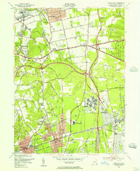
2 editions found
Other maps of this area

1901 · Babylon
USGS Topo · 1:62,500

1901 · Northport
USGS Topo · 1:62,500

1902 · Setauket
USGS Topo · 1:62,500

1902 · Fire Island
USGS Topo · 1:62,500

1903 · Babylon
USGS Topo · 1:62,500

1903 · Northport
USGS Topo · 1:62,500

1903 · Fire Island
USGS Topo · 1:62,500

1904 · Setauket
USGS Topo · 1:62,500

1904 · Islip
USGS Topo · 1:125,000

1919 · Setauket
USGS Topo · 1:62,500