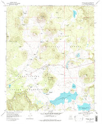
1969 Map of Greens Peak
USGS Topo · Published 1979About this map
Greens Peak dominates this high-altitude landscape of the White Mountains, reaching an elevation of 10,133 feet and serving as a prominent landmark with its summit Lookout Tower and Radio Towers. The 1969 survey captures a transitional boundary between the Apache National Forest and the Fort Apache Indian Reservation, where the terrain drops from volcanic peaks into broad meadows and cienegas. Ranching history is deeply embedded in the land, evidenced by the Colter Ranch and the nearby Old Colter Ranch. The map details an intricate network of water management features essential for high-country livestock and wildlife, from Carnero Lake and A-1 Lake to numerous named springs like Beehive Spr and Swinborne Spring. The presence of several cinder and gravel pits suggests the era's local material extraction for forest road maintenance and development.
Find a feature on this map
59 named features on this map. Tap any name to fly to it.
Don’t see what you’re looking for? This feature index may not catch every label — zoom into the map to look around manually.
Map Details
Editions of this 1969 Greens Peak Map
2 editions found
Other maps of this area

1886 · St Johns
USGS Topo · 1:250,000

1892 · St Johns
USGS Topo · 1:250,000

1922 · Nutrioso
USGS Topo · 1:125,000

1954 · Clifton
USGS Topo · 1:250,000

1954 · Saint Johns
USGS Topo · 1:250,000

1957 · Clifton
USGS Topo · 1:250,000

1957 · Saint Johns
USGS Topo · 1:250,000

1958 · Clifton
USGS Topo · 1:250,000

1958 · Saint Johns
USGS Topo · 1:250,000

1958 · Big Lake
USGS Topo · 1:62,500