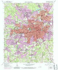
1951 Map of Greensboro
USGS Topo · Published 1986About this map
Greensboro is shown during a period of significant post-war expansion, with the city's urban core spreading into distinct neighborhoods like Fisher Park, Sunset Hills, and Nocho Park. The influence of the textile industry is clearly visible in the north, where the Revolution Mill Reservoir and industrial settlements such as White Oak, Revolution, and Proximity reflect the region's manufacturing roots. Institutional landmarks including the Womens College Univ of N C, Bennett College, and Greensboro High Sch anchor the residential landscape.
Find a feature on this map
127 named features on this map. Tap any name to fly to it.
Don’t see what you’re looking for? This feature index may not catch every label — zoom into the map to look around manually.
Map Details
Editions of this 1951 Greensboro Map
5 editions found
Other maps of this area

1950 · High Point East
USGS Topo · 1:24,000

1951 · High Point East
USGS Topo · 1:24,000

1951 · Guilford
USGS Topo · 1:24,000

1951 · Lake Brandt
USGS Topo · 1:24,000

1951 · Browns Summit
USGS Topo · 1:24,000

1951 · Greensboro
USGS Topo · 1:24,000

1952 · Mc Leansville
USGS Topo · 1:24,000

1953 · Raleigh
USGS Topo · 1:250,000

1953 · Greensboro
USGS Topo · 1:250,000

1954 · Greensboro
USGS Topo · 1:250,000
Featured Places
- Greensboro, NC
- Sedgefield Park, NC
- Starmount Forest, Greensboro
- Meadowood Homes, Greensboro
- Friendly Acres, Greensboro