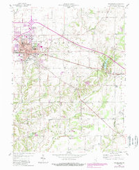
1958 Map of Greensburg
USGS Topo · Published 1988About this map
The Courthouse and surrounding city grid of Greensburg serve as the hub for this Decatur County landscape, where the New York Central railroad and the historic Michigan Road intersect. This survey illustrates the mid-century expansion of the city, with neighborhood schools like Billings Sch and Washington Sch serving the growing residential areas. Beyond the city limits, the terrain transitions into a patchwork of rural farmsteads and small crossroads communities, such as Knarr Corner and Slabtown.
Find a feature on this map
46 named features on this map. Tap any name to fly to it.
Don’t see what you’re looking for? This feature index may not catch every label — zoom into the map to look around manually.
Map Details
Editions of this 1958 Greensburg Map
4 editions found
Other maps of this area

1942 · Columbus
USGS Topo · 1:125,000

1946 · Osgood
USGS Topo · 1:24,000

1946 · New Point
USGS Topo · 1:24,000

1953 · Cincinnati
USGS Topo · 1:250,000

1957 · Cincinnati
USGS Topo · 1:250,000

1958 · Greensburg
USGS Topo · 1:24,000

1958 · Millhousen
USGS Topo · 1:24,000

1958 · Westport
USGS Topo · 1:24,000

1958 · Forest Hill
USGS Topo · 1:24,000

1958 · Clarksburg
USGS Topo · 1:24,000