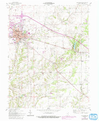
1958 Map of Greensburg
USGS Topo · Published 1993About this map
Greensburg serves as the hub of Decatur County, where the historic Courthouse and Post Office anchor a landscape transitioning from urban streets to productive Indiana farmland. Originally surveyed in the late 1950s with updates into the early 1990s, the map reveals a settlement pattern dictated by the Michigan road and a network of creeks. To the south and east, smaller crossroads communities like Knarr Corner, Slabtown, and Smyrna appear alongside rural landmarks such as Hazelrigg Sch and the Sand Creek Ch.
Find a feature on this map
40 named features on this map. Tap any name to fly to it.
Don’t see what you’re looking for? This feature index may not catch every label — zoom into the map to look around manually.
Map Details
Editions of this 1958 Greensburg Map
4 editions found
Other maps of this area

1942 · Columbus
USGS Topo · 1:125,000

1946 · Osgood
USGS Topo · 1:24,000

1946 · New Point
USGS Topo · 1:24,000

1953 · Cincinnati
USGS Topo · 1:250,000

1957 · Cincinnati
USGS Topo · 1:250,000

1958 · Greensburg
USGS Topo · 1:24,000

1958 · Millhousen
USGS Topo · 1:24,000

1958 · Westport
USGS Topo · 1:24,000

1958 · Forest Hill
USGS Topo · 1:24,000

1958 · Clarksburg
USGS Topo · 1:24,000