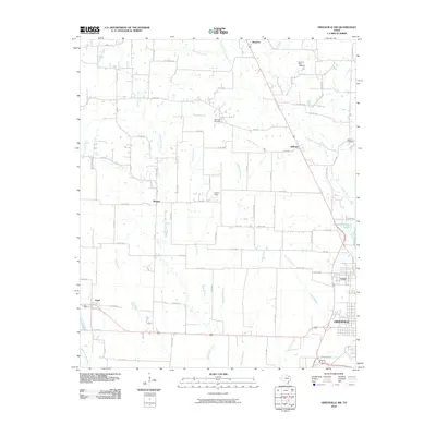
2010 Map of Greenville NW
USGS Topo · Published 2010About this map
Greenville serves as the focal point for this Hunt County landscape, where the city's northern industrial and residential edges meet the drainage basin of the Cowleech Fork Sabine River. The terrain is defined by a dense network of tributaries including East Caddo Creek, Elm Creek, and McWright Branch, which dictate the placement of rural settlements and transport routes. Smaller communities like Kingston, Kellogg, and Wagner are connected by a grid of farm-to-market roads and county lines, reflecting the area's agricultural heritage and gradual suburban expansion. Significant local markers include the Barnhart Boles Cemetery and the Greenville-Reservoir Number 6, which highlights the intersection of public infrastructure and historic land use. The presence of Flyers Field and the community of Peniel further illustrate the diverse development patterns characteristic of North Texas at the turn of the decade.
Find a feature on this map
73 named features on this map. Tap any name to fly to it.
Don’t see what you’re looking for? This feature index may not catch every label — zoom into the map to look around manually.
Map Details
Editions of this 2010 Greenville NW Map
This is the sole edition of this map. No revisions or reprints were ever made.
Other maps of this area

1930 · Farmersville
USGS Topo · 1:62,500

1954 · Sherman
USGS Topo · 1:250,000

1958 · Sherman
USGS Topo · 1:250,000

1960 · Pike
USGS Topo · 1:24,000

1962 · Greenville NW
USGS Topo · 1:24,000

1962 · Greenville SW
USGS Topo · 1:24,000

1962 · Greenville SE
USGS Topo · 1:24,000

1962 · Farmersville
USGS Topo · 1:24,000

1963 · Greenville NE
USGS Topo · 1:24,000
1963 · Josephine
USGS Topo · 1:24,000