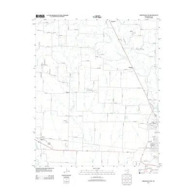
2013 Map of Greenville NW
USGS Topo · Published 2013About this map
The Cowleech Fork Sabine River and its numerous tributaries, such as E Caddo Cr and McWright Br, define the hydrological character of this north Texas landscape. This early 21st-century record shows the rural development of Hunt County, anchored by the community of Peniel in the southeast and Floyd in the southwest. The area is marked by a legacy of family-named landmarks and historical burial grounds, including the Barnhart Boles Cem, McWright Cem, and Money Cem. Transport and infrastructure are dominated by a dense grid of county roads and the presence of Flyers Field Airport near Wagner. The map also captures local water resources like the Greenville Reservoir Number Six, illustrating the modern management of the Sabine River headwaters.
Find a feature on this map
116 named features on this map. Tap any name to fly to it.
Don’t see what you’re looking for? This feature index may not catch every label — zoom into the map to look around manually.
Map Details
Editions of this 2013 Greenville NW Map
This is the sole edition of this map. No revisions or reprints were ever made.
Other maps of this area

1930 · Farmersville
USGS Topo · 1:62,500

1954 · Sherman
USGS Topo · 1:250,000

1958 · Sherman
USGS Topo · 1:250,000

1960 · Pike
USGS Topo · 1:24,000

1962 · Greenville NW
USGS Topo · 1:24,000

1962 · Greenville SW
USGS Topo · 1:24,000

1962 · Greenville SE
USGS Topo · 1:24,000

1962 · Farmersville
USGS Topo · 1:24,000

1963 · Greenville NE
USGS Topo · 1:24,000
1963 · Josephine
USGS Topo · 1:24,000