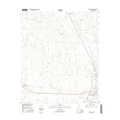
2016 Map of Greenville NW
USGS Topo · Published 2016About this map
Greenville serves as the focal point of this North Texas study, anchoring the southeastern corner where major transit corridors and suburban development meet the rural reaches of Hunt County. The landscape is defined by the winding course of the Cowleech Fork Sabine River and its numerous tributaries, including McWright Br and Holder Br, which drain the undulating terrain. A clear record of family landholdings and small-town heritage is preserved through the mapping of outlying settlements like Kingston, Peniel, and Floyd. Genealogists will find particular value in the documentation of local burial grounds such as Boles Cem, McWright Cem, and Money Cem, which remain as quiet landmarks alongside the expanding network of county roads and farm-to-market routes like FM 3427.
Find a feature on this map
119 named features on this map. Tap any name to fly to it.
Don’t see what you’re looking for? This feature index may not catch every label — zoom into the map to look around manually.
Map Details
Editions of this 2016 Greenville NW Map
This is the sole edition of this map. No revisions or reprints were ever made.
Other maps of this area

1930 · Farmersville
USGS Topo · 1:62,500

1954 · Sherman
USGS Topo · 1:250,000

1958 · Sherman
USGS Topo · 1:250,000

1960 · Pike
USGS Topo · 1:24,000

1962 · Greenville NW
USGS Topo · 1:24,000

1962 · Greenville SW
USGS Topo · 1:24,000

1962 · Greenville SE
USGS Topo · 1:24,000

1962 · Farmersville
USGS Topo · 1:24,000

1963 · Greenville NE
USGS Topo · 1:24,000
1963 · Josephine
USGS Topo · 1:24,000