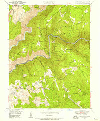
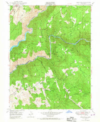
1949 Map of Greenwood
USGS Topo · Published 1957About this map
The confluence of the North Fork American River and the Middle Fork American River defines this rugged section of the Sierra Nevada foothills, where mining legacy and agricultural pockets intersect. Significant gold-mining sites such as the Grit Mine, Bowman Mine, and the Shenanigan Mine are scattered across the landscape, particularly near the settlement of Spanish Dry Diggings. The terrain is characterized by steep canyons like Maine Bar Canyon and prominent ridges such as the Georgetown Divide.
Find a feature on this map
63 named features on this map. Tap any name to fly to it.
Don’t see what you’re looking for? This feature index may not catch every label — zoom into the map to look around manually.
Map Details
Editions of this 1949 Greenwood Map
3 editions found

Other maps of this area

1888 · Smartsville
USGS Topo · 1:125,000

1891 · Sacramento
USGS Topo · 1:125,000

1891 · Colfax
USGS Topo · 1:125,000

1891 · Smartsville
USGS Topo · 1:125,000

1891 · Placerville
USGS Topo · 1:125,000

1892 · Sacramento
USGS Topo · 1:125,000

1892 · Placerville
USGS Topo · 1:125,000

1892 · Smartsville
USGS Topo · 1:125,000

1892 · Colfax
USGS Topo · 1:125,000

1893 · Placerville
USGS Topo · 1:125,000