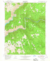
1949 Map of Greenwood
USGS Topo · Published 1967About this map
Spanish Dry Diggings and the community of Greenwood anchor this 1949 topographic survey of the Sierra Nevada foothills, revealing a landscape defined by gold-rush history and rugged river canyons. The Middle Fork American River and North Fork American River cut through the terrain, lined with historical bars such as Maine Bar, Buckeye Bar, and Texas Bar that recall the era of placer mining. Inland, the map documents the shift toward hard-rock operations with several named prospects including the Shenanigan Mine, Grit Mine, and Maltby Mine. This document captures the region's complex water infrastructure, tracing a system of ditches, a Siphon, and a Flume designed to move water across the Georgetown Divide. Along the northwestern edge, the Southern Pacific railroad passes through Applegate, while family names persist at landmarks like Drivers Flat, Butcher Ranch, and the Penobscot Farm.
Find a feature on this map
63 named features on this map. Tap any name to fly to it.
Don’t see what you’re looking for? This feature index may not catch every label — zoom into the map to look around manually.
Map Details
Editions of this 1949 Greenwood Map
3 editions found
Other maps of this area

1888 · Smartsville
USGS Topo · 1:125,000

1891 · Sacramento
USGS Topo · 1:125,000

1891 · Colfax
USGS Topo · 1:125,000

1891 · Smartsville
USGS Topo · 1:125,000

1891 · Placerville
USGS Topo · 1:125,000

1892 · Sacramento
USGS Topo · 1:125,000

1892 · Placerville
USGS Topo · 1:125,000

1892 · Smartsville
USGS Topo · 1:125,000

1892 · Colfax
USGS Topo · 1:125,000

1893 · Placerville
USGS Topo · 1:125,000