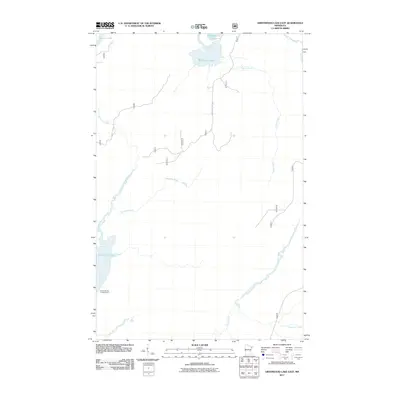
2011 Map of Greenwood Lake East
USGS Topo · Published 2011About this map
Greenwood Lake and the winding Stony River dominate this wilderness landscape in Lake County, as recorded in the early 21st century. The map detail highlights a network of waterways and forest access routes essential to the area's recreational and timber-focused economy. The Rocky Shores Campground on the southern shore of the lake serves as a primary point of human activity, while the interior is defined by smaller drainages such as Stockade Creek, Coyote Creek, and Mary Ann Creek. To the north, the McDougal Lakes feed into a system of creeks and rivers that move through the dense woodland. This era of the Superior National Forest region is mapped with attention to designated routes like McDougal Lake Rd and Forest Rte 942, which provide the backbone for traversing this lake-rich terrain.
Find a feature on this map
12 named features on this map. Tap any name to fly to it.
Don’t see what you’re looking for? This feature index may not catch every label — zoom into the map to look around manually.
Map Details
Editions of this 2011 Greenwood Lake East Map
This is the sole edition of this map. No revisions or reprints were ever made.
Other maps of this area

1953 · Whyte
USGS Topo · 1:62,500

1954 · Greenwood Lake
USGS Topo · 1:62,500

1954 · Silver Bay
USGS Topo · 1:62,500

1954 · Two Harbors
USGS Topo · 1:250,000

1955 · Isabella
USGS Topo · 1:62,500

1957 · Two Harbors
USGS Topo · 1:250,000

1958 · Two Harbors
USGS Topo · 1:250,000

1964 · Two Harbors
USGS Topo · 1:250,000

1976 · Two Harbors
USGS Topo · 1:100,000
1981 · Slate Lake West
USGS Topo · 1:24,000