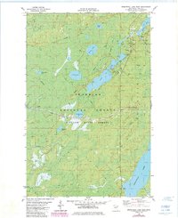
1982 Map of Greenwood Lake West
USGS Topo · Published 1985About this map
Superior National Forest and Finland State Forest converge in this northern landscape, which is defined by a dense network of glacial lakes and marshy lowland. Large bodies of water like Sand Lake and the northern reaches of Greenwood Lake are connected by the meandering Stony River. The presence of a Mining Railroad cutting through the center of the sheet reflects the region's industrial heritage, specifically the extraction of taconite or other iron ores common to the Arrowhead region. Transportation in this era relied heavily on seasonal routes, evidenced by the numerous Winter Trails and Snowmobile Trails that crisscross the wetlands. Smaller, isolated water bodies such as Lobo Lake, Bonga Lake, and Ridgepole Lake are scattered throughout the timberland, often accessible only by these specialized paths or by the Ridgepole Creek drainage system.
Find a feature on this map
20 named features on this map. Tap any name to fly to it.
Don’t see what you’re looking for? This feature index may not catch every label — zoom into the map to look around manually.
Map Details
Editions of this 1982 Greenwood Lake West Map
2 editions found
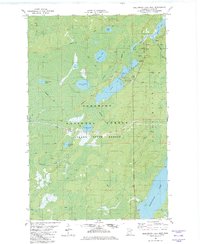
Other maps of this area

1952 · Babbitt SE
USGS Topo · 1:24,000

1952 · Babbitt NE
USGS Topo · 1:24,000

1953 · Whyte
USGS Topo · 1:62,500

1954 · Greenwood Lake
USGS Topo · 1:62,500

1954 · Two Harbors
USGS Topo · 1:250,000

1957 · Two Harbors
USGS Topo · 1:250,000

1957 · Brimson
USGS Topo · 1:62,500

1958 · Two Harbors
USGS Topo · 1:250,000

1964 · Two Harbors
USGS Topo · 1:250,000

1976 · Two Harbors
USGS Topo · 1:100,000