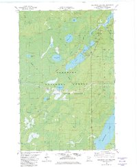
1982 Map of Greenwood Lake West
USGS Topo · Published 1982About this map
Superior National Forest and Finland State Forest dominate this Lake County landscape, illustrating a wilderness shaped by resource extraction and seasonal travel in the early 1980s. The presence of the Mining Railroad cutting through the center of the sheet reflects the region's industrial ties, while numerous Winter Trails and Snowmobile Trails indicate the importance of seasonal access across this water-rich terrain. Notable water bodies include the expansive Sand Lake and the northern portion of Greenwood Lake, connected by systems like Stony River and Ridgepole Creek. For researchers, the map identifies specific points of interest such as a Public Access site on Greenwood Lake and scattered Gravel Pits, providing a clear record of land use and recreational infrastructure during this period.
Find a feature on this map
19 named features on this map. Tap any name to fly to it.
Don’t see what you’re looking for? This feature index may not catch every label — zoom into the map to look around manually.
Map Details
Editions of this 1982 Greenwood Lake West Map
2 editions found
Other maps of this area

1952 · Babbitt SE
USGS Topo · 1:24,000

1952 · Babbitt NE
USGS Topo · 1:24,000

1953 · Whyte
USGS Topo · 1:62,500

1954 · Greenwood Lake
USGS Topo · 1:62,500

1954 · Two Harbors
USGS Topo · 1:250,000

1957 · Two Harbors
USGS Topo · 1:250,000

1957 · Brimson
USGS Topo · 1:62,500

1958 · Two Harbors
USGS Topo · 1:250,000

1964 · Two Harbors
USGS Topo · 1:250,000

1976 · Two Harbors
USGS Topo · 1:100,000