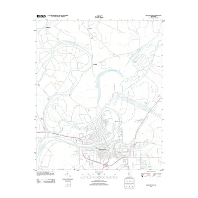
2012 Map of Greenwood
USGS Topo · Published 2012About this map
Greenwood sits at the vital confluence where the Tallahatchie River and the Yalobusha River join to form the Yazoo River. This hydrological nexus defines the landscape, which is marked by numerous oxbow lakes and bayous such as Hells Halfacre, Two Mile Lake, and Peluciar Bayou. The town's grid expands eastward from the riverbanks, reaching toward the Leflore County Penal Farm and the outlying community of Grenada Junction.
Find a feature on this map
102 named features on this map. Tap any name to fly to it.
Don’t see what you’re looking for? This feature index may not catch every label — zoom into the map to look around manually.
Map Details
Editions of this 2012 Greenwood Map
This is the sole edition of this map. No revisions or reprints were ever made.
Other maps of this area

1931 · Schlater
USGS Topo · 1:48,000

1934 · Schlater
USGS Topo · 1:62,500

1936 · Greenwood
USGS Topo · 1:62,500

1939 · Schlater
USGS Topo · 1:62,500

1940 · Seven Pines
USGS Topo · 1:62,500

1940 · Greenwood
USGS Topo · 1:62,500

1953 · Greenwood
USGS Topo · 1:250,000

1956 · Greenwood
USGS Topo · 1:250,000

1957 · Greenwood
USGS Topo · 1:62,500

1957 · Seven Pines
USGS Topo · 1:62,500