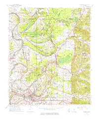
1957 Map of Greenwood
USGS Topo · Published 1976About this map
The Tallahatchie River and Yalobusha River converge here to form the Yazoo River, creating a landscape defined by intricate waterways and oxbow lakes like Six Mile Lake and McIntyre Lake. This mid-century environment is densely populated with small rural communities and tenant-farming infrastructure, anchored by the city of Greenwood and the hub at Money. The density of country churches and cemeteries, such as Sweet Home Ch & Cem and Cypress Grove Ch & Cem, reveals the deeply rooted social fabric of the Mississippi Delta. The Illinois Central Railroad serves as the primary artery for the region's agricultural economy, connecting outposts like Leflore and Avalon. Notable landmarks from this era include the Glen Burr Race Track Sch and various plantations like Wildwood, reflecting the local economy and social life before widespread mechanization changed the rural landscape.
Find a feature on this map
95 named features on this map. Tap any name to fly to it.
Don’t see what you’re looking for? This feature index may not catch every label — zoom into the map to look around manually.
Map Details
Editions of this 1957 Greenwood Map
3 editions found

Other maps of this area

1931 · Schlater
USGS Topo · 1:48,000

1931 · Sumner
USGS Topo · 1:48,000

1932 · Philipp
USGS Topo · 1:48,000

1934 · Schlater
USGS Topo · 1:62,500

1935 · Sumner
USGS Topo · 1:62,500

1935 · Philipp
USGS Topo · 1:62,500

1936 · Greenwood
USGS Topo · 1:62,500

1939 · Schlater
USGS Topo · 1:62,500

1939 · Sumner
USGS Topo · 1:62,500

1939 · Philipp
USGS Topo · 1:62,500