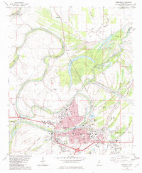
1982 Map of Greenwood
USGS Topo · Published 1982About this map
The Yazoo River takes form at the confluence of the Tallahatchie River and Yalobusha River just north of Greenwood. This delta landscape is defined by its winding waterways and the heavy presence of the Illinois Central Gulf Railroad, which skirts the eastern edge of the city. Notable for local history, the map depicts several rural churches and burial sites, including Little Zion Ch and Loggins Cem, scattered across the agricultural flats. In the city center, the Courthouse and City Hall anchor the grid, while the Florewood River Plantation Museum provides a specific focal point for the region's heritage west of the main settlement. The presence of the Sand Creek Cutoff and various bayous like Williamson Bayou reflects the complex water management essential to this riverine environment.
Find a feature on this map
56 named features on this map. Tap any name to fly to it.
Don’t see what you’re looking for? This feature index may not catch every label — zoom into the map to look around manually.
Map Details
Editions of this 1982 Greenwood Map
This is the sole edition of this map. No revisions or reprints were ever made.
Other maps of this area

1931 · Schlater
USGS Topo · 1:48,000

1934 · Schlater
USGS Topo · 1:62,500

1936 · Greenwood
USGS Topo · 1:62,500

1939 · Schlater
USGS Topo · 1:62,500

1940 · Seven Pines
USGS Topo · 1:62,500

1940 · Greenwood
USGS Topo · 1:62,500

1953 · Greenwood
USGS Topo · 1:250,000

1956 · Greenwood
USGS Topo · 1:250,000

1957 · Greenwood
USGS Topo · 1:62,500

1957 · Seven Pines
USGS Topo · 1:62,500