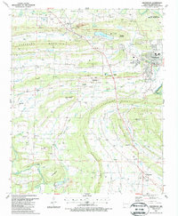
1987 Map of Greenwood
USGS Topo · Published 1988About this map
Greenwood serves as the focal point of this late 20th-century landscape, housing the county Courthouse and anchored by Bell Park near the Greenwood Corp Bdy. The geography is defined by the heavy presence of energy infrastructure, with numerous Gas Wells and a Pipeline cutting across the terrain alongside the natural features of Backbone Mountain and Devils Backbone Ridge. The map documents a transition from the area's industrial past to its modern character, showing an Old Railroad grade and a Coal Wash Yard near Billcol Mountain alongside active resource extraction like the Strip Mine. Genealogists will find a wealth of local markers, from the clusters at New Jenny Lind and Old Jenny Lind to rural sanctuaries like Mt Zion Ch and Shady Grove Ch, and family resting places including Stroud Cem and Lovelace Cem.
Find a feature on this map
66 named features on this map. Tap any name to fly to it.
Don’t see what you’re looking for? This feature index may not catch every label — zoom into the map to look around manually.
Map Details
Editions of this 1987 Greenwood Map
This is the sole edition of this map. No revisions or reprints were ever made.
Other maps of this area

1879 · Fort Smith
USGS Topo · 1:62,500

1887 · Van Buren
USGS Topo · 1:62,500

1887 · Greenwood
USGS Topo · 1:62,500

1890 · Fort Smith
USGS Topo · 1:125,000

1906 · Lavaca
USGS Topo · 1:62,500

1906 · Barber
USGS Topo · 1:62,500

1943 · Fort Smith
USGS Topo · 1:125,000

1946 · Fort Smith
USGS Topo · 1:250,000

1947 · Lavaca
USGS Topo · 1:62,500

1947 · Van Buren
USGS Topo · 1:62,500