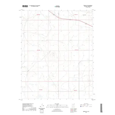
2020 Map of Grenville SW
USGS Topo · Published 2020About this map
Seneca Cr winds through the northern sections of this High Plains landscape, a characteristic watercourse in a region defined by its wide-reaching drainage patterns and subtle relief. The terrain is marked by the presence of Cherry Canyon in the northeast, where the elevation changes become more pronounced against the surrounding plains. This survey documents the rural infrastructure of Union County as it existed in the early 21st century, showing the grid of section lines and the essential rural transport network including Hittson Rd and Co Rd A012. The distribution of intermittent water features and depression contours suggests a landscape that manages seasonal moisture, typical for this part of New Mexico. The map provides a clear record of land division and remote road access within the various townships, from t28n r30e down to t26n r31e.
Find a feature on this map
10 named features on this map. Tap any name to fly to it.
Don’t see what you’re looking for? This feature index may not catch every label — zoom into the map to look around manually.
Map Details
Editions of this 2020 Grenville SW Map
This is the sole edition of this map. No revisions or reprints were ever made.
Other maps of this area

1954 · Dalhart
USGS Topo · 1:250,000

1958 · Dalhart
USGS Topo · 1:250,000

1962 · Dalhart
USGS Topo · 1:250,000

1972 · Little Grande
USGS Topo · 1:24,000

1972 · Cow Mountain
USGS Topo · 1:24,000
1973 · Wetherly Lake
USGS Topo · 1:24,000

1973 · Grenville SW
USGS Topo · 1:24,000

1973 · Snyder Lake
USGS Topo · 1:24,000

1973 · Tripod Mountain
USGS Topo · 1:24,000
1973 · Blind Gap
USGS Topo · 1:24,000