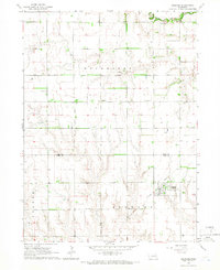
1965 Map of Gresham
USGS Topo · Published 1966About this map
Gresham serves as the primary hub of activity in this mid-1960s agricultural survey, situated along a prominent Railroad line. The surrounding landscape is defined by the township divisions of Hackberry, Stewart, and Thayer, showcasing a highly organized grid of rural infrastructure. The upper portion of the quadrangle is bisected by the Big Blue River, while the lower sections feature a dense network of farmstead wells. This map is particularly valuable for genealogical research, documenting several distinct burial sites including Hoffer Cem in the west, Blue Ridge Cem in the north-central area, and Cedar Lawn Cem located on the outskirts of the main settlement. Community life is further evidenced by the Wayland Ch, standing as a landmark among the expansive fields near the Polk Co York Co boundary line.
Find a feature on this map
13 named features on this map. Tap any name to fly to it.
Don’t see what you’re looking for? This feature index may not catch every label — zoom into the map to look around manually.
Map Details
Editions of this 1965 Gresham Map
This is the sole edition of this map. No revisions or reprints were ever made.
Other maps of this area

1896 · Stromsburg
USGS Topo · 1:125,000

1898 · York
USGS Topo · 1:125,000

1899 · David City
USGS Topo · 1:125,000

1899 · York
USGS Topo · 1:125,000

1934 · Utica
USGS Topo · 1:62,500

1937 · Utica
USGS Topo · 1:62,500

1955 · Fremont
USGS Topo · 1:250,000

1955 · Lincoln
USGS Topo · 1:250,000

1957 · Fremont
USGS Topo · 1:250,000

1957 · Lincoln
USGS Topo · 1:250,000