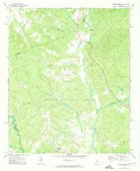
1972 Map of Greshamville
USGS Topo · Published 1974About this map
Greshamville and Wrayswood serve as the primary focal points of this 1970s survey, illustrating the rural character of Greene County. The eastern reach of the Oconee National Forest dominates the central landscape, punctuated by local landmarks like the Lookout Tower and a Sandpit near the western border. The map documents a spiritual geography through several country congregations, including New Hope Ch, Fork Chapel, and Spring Creek Ch, each often accompanied by small family or community cemeteries.
Find a feature on this map
26 named features on this map. Tap any name to fly to it.
Don’t see what you’re looking for? This feature index may not catch every label — zoom into the map to look around manually.
Map Details
Editions of this 1972 Greshamville Map
2 editions found
Other maps of this area

1953 · Athens
USGS Topo · 1:250,000

1958 · Athens
USGS Topo · 1:250,000

1959 · Athens
USGS Topo · 1:250,000

1963 · Athens
USGS Topo · 1:250,000

1964 · Barnett Shoals
USGS Topo · 1:24,000

1964 · Watkinsville
USGS Topo · 1:24,000

1971 · Maxeys
USGS Topo · 1:24,000

1972 · Penfield
USGS Topo · 1:24,000

1972 · Buckhead
USGS Topo · 1:24,000

1972 · Apalachee
USGS Topo · 1:24,000