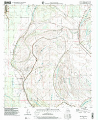
1998 Map of Gretna Green
USGS Topo · Published 2002About this map
Big Choctaw Bayou and Little Choctaw Bayou weave a complex drainage pattern across this Tensas Parish landscape, where the legacy of river-bottom agriculture is evident in the sprawling Wavertree Plantation and named settlements like Shady Grove and Gretna Green. This late-twentieth-century study shows a rural environment deeply rooted in faith and community, marked by a high density of country churches including New China Grove Ch, New Hope Ch, and Spring Hill Ch. The terrain is defined by the Holly Ridge elevation and a series of oxbow-remnant water bodies such as Lake Formosa, Snodgrass Lake, and Turkey Lake. Infrastructure for drainage and transport is highlighted by the Lake St Peter Canal in the south, while numerous petroleum Drill Holes scattered across the township lines indicate the area's mid-century industrial interests.
Find a feature on this map
44 named features on this map. Tap any name to fly to it.
Don’t see what you’re looking for? This feature index may not catch every label — zoom into the map to look around manually.
Map Details
Editions of this 1998 Gretna Green Map
This is the sole edition of this map. No revisions or reprints were ever made.
Other maps of this area

1909 · Delta Bridge
USGS Topo · 1:24,000

1935 · Winnsboro
USGS Topo · 1:62,500

1935 · Shackleford Lake
USGS Topo · 1:62,500

1939 · Locust Ridge
USGS Topo · 1:62,500

1941 · Sicily Island
USGS Topo · 1:62,500

1953 · Natchez
USGS Topo · 1:250,000

1955 · Jackson
USGS Topo · 1:250,000

1956 · Natchez
USGS Topo · 1:250,000

1957 · Sicily Island
USGS Topo · 1:62,500

1958 · Shackleford Lake
USGS Topo · 1:62,500