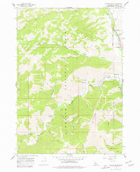
1967 Map of Griffin Butte
USGS Topo · Published 1977About this map
Ketchum sits at the edge of the Big Wood River in this 1960s survey, showing the early infrastructure of a developing recreation area. The landscape is defined by the steep rises of Bald Mountain and Griffin Butte, while the drainage of Warm Springs Creek serves as a primary corridor for mountain access. Geothermal activity is a prominent feature of the local geography, marked by Guyer Hot Springs and Warfield Hot Spring. Evidence of the region's diverse history is visible in the transition from resource extraction to leisure, with Prospects and a Tailings Pond appearing near modern recreational sites like the Warm Springs Campground and a Golf Course. Numerous narrow valleys, including Adams Gulch and Bassett Gulch, are etched with a network of trails and jeep trails used for forest management and back-country exploration.
Find a feature on this map
36 named features on this map. Tap any name to fly to it.
Don’t see what you’re looking for? This feature index may not catch every label — zoom into the map to look around manually.
Map Details
Editions of this 1967 Griffin Butte Map
2 editions found
Other maps of this area

1895 · Hailey
USGS Topo · 1:125,000

1897 · Hailey
USGS Topo · 1:125,000

1900 · Sawtooth
USGS Topo · 1:125,000

1955 · Hailey
USGS Topo · 1:250,000

1959 · Hailey
USGS Topo · 1:250,000

1962 · Hailey
USGS Topo · 1:250,000

1967 · Rock Roll Canyon
USGS Topo · 1:24,000

1967 · Mahoney Butte
USGS Topo · 1:24,000

1967 · Sun Valley
USGS Topo · 1:24,000

1967 · Hailey
USGS Topo · 1:24,000