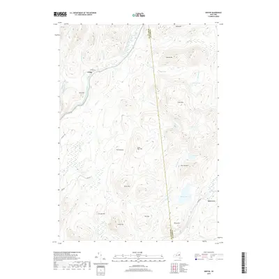
2019 Map of Griffin
USGS Topo · Published 2019About this map
The East Branch Sacandaga River carves through this Adirondack landscape, passing the small settlement of Griffin at the junction of Teachout Rd. This northern New York terrain is defined by high peaks and scattered water bodies, where Auger Falls and Cotter Swamp break the mountain drainage. In the southeast, Bakertown sits near the headwaters of East Stony Creek, connected by Harrisburg Rd. The map reveals a high density of named summits, including the distinct Steve Bigle Mtn, Georgia Mtn, and Smith Mtn, alongside isolated water features like Wilcox Lake and Shiras Pond. This 2019 survey documents a region where contemporary roads like Windfall Rd and Dorr Rd navigate a complex network of wetlands such as East Vly and Taylor Vly, illustrating the persistent wild character of the Hamilton and Warren County border.
Find a feature on this map
42 named features on this map. Tap any name to fly to it.
Don’t see what you’re looking for? This feature index may not catch every label — zoom into the map to look around manually.
Map Details
Editions of this 2019 Griffin Map
This is the sole edition of this map. No revisions or reprints were ever made.
Other maps of this area

1898 · Thirteenth Lake
USGS Topo · 1:62,500

1899 · Indian Lake
USGS Topo · 1:62,500

1902 · Indian Lake
USGS Topo · 1:62,500

1907 · Lake Pleasant
USGS Topo · 1:62,500

1910 · Stony Creek
USGS Topo · 1:62,500

1950 · Utica
USGS Topo · 1:250,000

1954 · Lake Pleasant
USGS Topo · 1:62,500

1954 · Thirteenth Lake
USGS Topo · 1:62,500

1954 · Indian Lake
USGS Topo · 1:62,500

1954 · Harrisburg
USGS Topo · 1:62,500