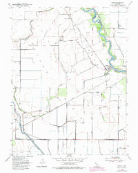
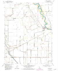
1954 Map of Grimes
USGS Topo · Published 1980About this map
The Sacramento River winds through this Central Valley landscape, defining the boundary between Colusa and Sutter counties. Near the river's edge, the town of Grimes serves as a focal point for the surrounding agricultural basins, including Mormon Basin and Munson Jimenez Basin. The map captures the specialized water management and transportation infrastructure of the mid-20th century, with the Colusa Basin Drainage Canal and Tule Canal cutting straight lines across the alluvial floor. The Southern Pacific railroad traverses the valley, featuring stops like Sycamore Siding and the small settlement of Graino. Genealogists may find particular value in the locations of the Grand Island Cemetery and Grand Island School, which together with named river features like Ogden Bend and Twentymile Bar, reveal the historical fabric of this riverine community.
Find a feature on this map
35 named features on this map. Tap any name to fly to it.
Don’t see what you’re looking for? This feature index may not catch every label — zoom into the map to look around manually.
Map Details
Editions of this 1954 Grimes Map
5 editions found
Other maps of this area

1888 · Marysville
USGS Topo · 1:125,000

1891 · Marysville
USGS Topo · 1:125,000

1894 · Marysville
USGS Topo · 1:125,000

1895 · Marysville
USGS Topo · 1:125,000

1905 · Harrington
USGS Topo · 1:24,000

1907 · Dunnigan
USGS Topo · 1:62,500

1907 · Colusa
USGS Topo · 1:62,500

1911 · Grimes
USGS Topo · 1:31,680

1912 · Marysville Buttes
USGS Topo · 1:31,680

1912 · Meridian
USGS Topo · 1:31,680