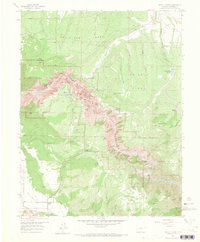
1957 Map of Grizzly Ridge
USGS Topo · Published 1965About this map
The dramatic gorge of the Black Canyon of the Gunnison National Monument dominates this mid-century landscape, revealing a intricate network of canyon floor features and rim-side overlooks. The map documents the complex geography of the Gunnison River as it cuts between Fruitland Mesa and Grizzly Ridge. Significant logistical points for mid-century visitors are clearly marked, including the South Rim Ranger Sta and the North Rim Ranger Sta, alongside named geological formations such as the Painted Wall, Chasm View, and The Narrows.
Find a feature on this map
44 named features on this map. Tap any name to fly to it.
Don’t see what you’re looking for? This feature index may not catch every label — zoom into the map to look around manually.
Map Details
Editions of this 1957 Grizzly Ridge Map
5 editions found
Other maps of this area

1909 · Montrose
USGS Topo · 1:125,000

1911 · Montrose
USGS Topo · 1:125,000

1955 · Black Ridge
USGS Topo · 1:24,000

1955 · Red Rock Canyon
USGS Topo · 1:24,000

1956 · Cimarron
USGS Topo · 1:24,000

1956 · Montrose
USGS Topo · 1:250,000

1957 · Cathedral Peak
USGS Topo · 1:24,000

1957 · Cerro Summit
USGS Topo · 1:24,000

1957 · Grizzly Ridge
USGS Topo · 1:24,000

1959 · Montrose
USGS Topo · 1:250,000