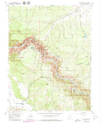
1957 Map of Grizzly Ridge
USGS Topo · Published 1979About this map
Black Canyon of the Gunnison National Monument dominates this mid-century topographic survey, revealing the dramatic verticality of the canyon floor where the Gunnison River carves through Black Mesa and Vernal Mesa. The map illustrates a landscape of extreme elevation changes, from the sheer depths at The Narrows and Chasm View to the high points of Grizzly Ridge and Green Mtn. This era shows the intricate water management required for the surrounding plateau, specifically the presence of the Gunnison Tunnel and the Vernal Mesa Ditch, which directed water towards agricultural areas like Fruitland and Orchard Corner. The inclusion of the Curecanti National Recreational Area reflects the evolving federal management of these lands, while landmarks such as the North Rim Ranger Sta and East Portal mark the thin line of human infrastructure in this steep terrain.
Find a feature on this map
59 named features on this map. Tap any name to fly to it.
Don’t see what you’re looking for? This feature index may not catch every label — zoom into the map to look around manually.
Map Details
Editions of this 1957 Grizzly Ridge Map
5 editions found
Other maps of this area

1909 · Montrose
USGS Topo · 1:125,000

1911 · Montrose
USGS Topo · 1:125,000

1955 · Black Ridge
USGS Topo · 1:24,000

1955 · Red Rock Canyon
USGS Topo · 1:24,000

1956 · Cimarron
USGS Topo · 1:24,000

1956 · Montrose
USGS Topo · 1:250,000

1957 · Cathedral Peak
USGS Topo · 1:24,000

1957 · Cerro Summit
USGS Topo · 1:24,000

1957 · Grizzly Ridge
USGS Topo · 1:24,000

1959 · Montrose
USGS Topo · 1:250,000