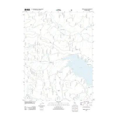
2012 Map of Grizzly Valley
USGS Topo · Published 2012About this map
Lake Davis dominates the eastern landscape of this Plumas County region, its irregular shoreline forming prominent points like Lighting Tree Point and sheltered waters at Jenkins Cove. The terrain is defined by a series of distinct upland basins, including Red Clover Valley to the north and Grizzly Valley which cradles the lake. Transportation through these elevations relies on routes like the Beckworth-Taylorsville Rd, which passes through the small outpost at Gate Place. Small settlements and seasonal landmarks such as Midway House and Sheep Camp provide evidence of the area's grazing and transit history. The drainage network is complex, with Big Grizzly Cr and Red Clover Cr carving through the valleys, supported by smaller sources like Coldwater Spring. To the south, the terrain rises toward Threemile Rock, overlooking Threemile Valley and the meadows of Happy Valley.
Find a feature on this map
27 named features on this map. Tap any name to fly to it.
Don’t see what you’re looking for? This feature index may not catch every label — zoom into the map to look around manually.
Map Details
Editions of this 2012 Grizzly Valley Map
This is the sole edition of this map. No revisions or reprints were ever made.
Other maps of this area

1886 · Honey Lake
USGS Topo · 1:250,000

1890 · Sierraville
USGS Topo · 1:125,000

1891 · Downieville
USGS Topo · 1:125,000

1891 · Honey Lake
USGS Topo · 1:250,000

1892 · Sierraville
USGS Topo · 1:125,000

1893 · Honey Lake
USGS Topo · 1:250,000

1893 · Downieville
USGS Topo · 1:125,000

1894 · Sierraville
USGS Topo · 1:125,000

1895 · Downieville
USGS Topo · 1:125,000

1896 · Downieville
USGS Topo · 1:125,000