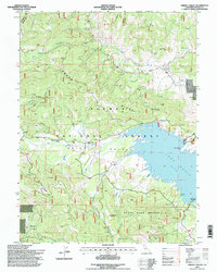
1994 Map of Grizzly Valley
USGS Topo · Published 1998About this map
Lake Davis dominates the center of this Plumas County landscape, its irregular shoreline defined by points like Lightning Tree Point and inlets such as Jenkins Cove. The map documents a transition in land use, noting former activity at Midway House (Site) and Gate Place (Site) within the boundaries of the Plumas National Forest. High points like Mt Ingalls and Threemile Rock overlook a complex drainage system where Grizzly Creek and Red Clover Creek converge. To the south, the State Game Refuge 1-V occupies the terrain between Grizzly Ridge and the lake, while modern recreation is marked by the Old Camp 5 Boat Ramp. This survey provides a precise look at the 1990s geography of the Grizzly Valley and its surrounding peaks.
Find a feature on this map
37 named features on this map. Tap any name to fly to it.
Don’t see what you’re looking for? This feature index may not catch every label — zoom into the map to look around manually.
Map Details
Editions of this 1994 Grizzly Valley Map
This is the sole edition of this map. No revisions or reprints were ever made.
Other maps of this area

1886 · Honey Lake
USGS Topo · 1:250,000

1890 · Sierraville
USGS Topo · 1:125,000

1891 · Downieville
USGS Topo · 1:125,000

1891 · Honey Lake
USGS Topo · 1:250,000

1892 · Sierraville
USGS Topo · 1:125,000

1893 · Honey Lake
USGS Topo · 1:250,000

1893 · Downieville
USGS Topo · 1:125,000

1894 · Sierraville
USGS Topo · 1:125,000

1895 · Downieville
USGS Topo · 1:125,000

1896 · Downieville
USGS Topo · 1:125,000