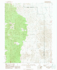
1989 Map of Groom Range
USGS Topo · Published 1989About this map
Groom Range dominates this 1980s landscape within the high desert of Lincoln County, punctuated by the high peak of Bald Mountain. The eastern portion of the sheet transitions into the wide expanse of Tikaboo Valley, characterized by a network of drainage channels and limited vehicular access. Most of the terrain is defined by its status as part of the Nellis Air Force Range, a designation that fundamentally limited civilian movement and development throughout the late twentieth century.
Find a feature on this map
7 named features on this map. Tap any name to fly to it.
Don’t see what you’re looking for? This feature index may not catch every label — zoom into the map to look around manually.
Map Details
Editions of this 1989 Groom Range Map
This is the sole edition of this map. No revisions or reprints were ever made.
Other maps of this area

1942 · Emigrant Valley
USGS Topo · 1:125,000

1942 · Penoyer Valley
USGS Topo · 1:125,000

1952 · White Blotch Springs
USGS Topo · 1:62,500

1952 · Groom Mine
USGS Topo · 1:62,500

1954 · Caliente
USGS Topo · 1:250,000

1959 · Caliente
USGS Topo · 1:250,000

1964 · Tempiute Mtn
USGS Topo · 1:62,500
1983 · Groom Range SE
USGS Topo · 1:24,000
1983 · Groom Range NE
USGS Topo · 1:24,000

1985 · Pahranagat Range
USGS Topo · 1:100,000