
1964 Map of Tempiute Mtn
USGS Topo · Published 1965About this map
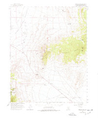
Tempiute Mountain and the high ridges of the Timpahute Range dominate this mid-century survey of Lincoln County. The landscape is defined by its deep mining roots, most notably the Lincoln Mine and the Tempiute Historic Site, which sit on the western flanks of the range overlooking Sand Spring Valley. This area represents a classic Great Basin mining environment, where small-scale operations like the Schofield Mine and Andies Mine were established near vital water sources such as Penoyer Springs and Monte Spring. Evidence of high-altitude scientific and logistics activity is found at the Lincoln Mine PIBAL Station and a remote Landing Strip in the southern flats. Significant relief is mapped through Wildcat Canyon and peaks like Grants Peak, providing a detailed view of the rugged transition between the valley floors and the mineral-rich mountain summits.
Find a feature on this map
30 named features on this map. Tap any name to fly to it.
Don’t see what you’re looking for? This feature index may not catch every label — zoom into the map to look around manually.
Map Details
Editions of this 1964 Tempiute Mtn Map
2 editions found
Other maps of this area

1942 · Emigrant Valley
USGS Topo · 1:125,000

1942 · Penoyer Valley
USGS Topo · 1:125,000

1945 · Alamo
USGS Topo · 1:125,000

1952 · White Blotch Springs
USGS Topo · 1:62,500

1952 · Groom Mine
USGS Topo · 1:62,500

1954 · Caliente
USGS Topo · 1:250,000

1959 · Caliente
USGS Topo · 1:250,000
1983 · Crescent Reservoir
USGS Topo · 1:24,000
1983 · Groom Range NE
USGS Topo · 1:24,000

1985 · Pahranagat Range
USGS Topo · 1:100,000