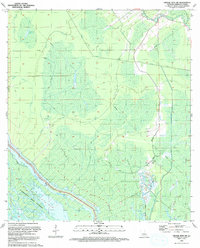
1992 Map of Grosse Tete SW
USGS Topo · Published 1992About this map
Atchafalaya Basin Floodway dominates the landscape of this portion of Iberville Parish, characterized by an intricate network of wetlands, canals, and natural waterways. The southeastern corner reveals significant industrial footprint with the Bayou Blue Oil Field, where a dense concentration of infrastructure sits amidst the swampy terrain. Hydrological control is a defining theme of the area, anchored by the Maringouin Protection Levee which separates the wilder reaches of the floodway from more managed sections. Water bodies like Smith Lake, Halfway Lake, and Bogan Bayou weave through the basin, illustrating the complex drainage patterns of the Louisiana lowlands. The presence of numerous four-wheel-drive trails and pipelines suggests a landscape heavily utilized for resource extraction and water management, while the Atchafalaya River itself serves as the primary artery for this massive alluvial system.
Find a feature on this map
18 named features on this map. Tap any name to fly to it.
Don’t see what you’re looking for? This feature index may not catch every label — zoom into the map to look around manually.
Map Details
Editions of this 1992 Grosse Tete SW Map
This is the sole edition of this map. No revisions or reprints were ever made.
Other maps of this area

1935 · Osca Bayou
USGS Topo · 1:62,500

1935 · Chicot Lake
USGS Topo · 1:62,500

1940 · Grosse Tete
USGS Topo · 1:62,500

1941 · Loreauville
USGS Topo · 1:62,500

1953 · Crescent
USGS Topo · 1:24,000

1953 · Cow Bayou
USGS Topo · 1:24,000

1953 · Lobdell
USGS Topo · 1:24,000

1953 · Pigeon Bay
USGS Topo · 1:24,000

1953 · Maringouin
USGS Topo · 1:24,000

1953 · Addis
USGS Topo · 1:24,000