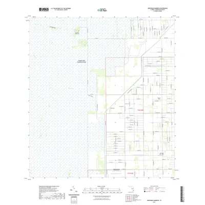
2021 Map of Grossman Hammock
USGS Topo · Published 2021About this map
Everglades National Park dominates the western half of this Florida landscape, where the vast wetlands of The Everglades meet the encroaching agricultural and residential grid of Miami-Dade County. The transition is marked by a series of north-south avenues and lateral drainage structures, including the Princeton Canal Number C-102 and Mowry Canal Number C-103. In the north, Lake Chekika sits near Grossman Hammock and Grossman Ridge, providing a rare elevation change in the otherwise level terrain. The eastern section shows a mix of farming and aviation, with several small landing strips such as Richards Field and The Wright Place Airport situated alongside groves and nurseries. To the south, the Miami Homestead General Aviation airport highlights the importance of light aircraft in this corner of the state, where long-established thoroughfares like Hainlin Mill Dr and Silver Palm Dr cross the rural landscape.
Find a feature on this map
91 named features on this map. Tap any name to fly to it.
Don’t see what you’re looking for? This feature index may not catch every label — zoom into the map to look around manually.
Map Details
Editions of this 2021 Grossman Hammock Map
This is the sole edition of this map. No revisions or reprints were ever made.
Other maps of this area

1949 · South Miami NW
USGS Topo · 1:24,000

1949 · Goulds
USGS Topo · 1:24,000

1950 · Homestead
USGS Topo · 1:24,000

1955 · South Miami NW
USGS Topo · 1:24,000

1956 · Goulds
USGS Topo · 1:24,000

1956 · Grossman Hammock
USGS Topo · 1:24,000

1956 · Homestead
USGS Topo · 1:24,000

1956 · Royal Palm Ranger Station
USGS Topo · 1:24,000

1956 · Miami
USGS Topo · 1:250,000

1958 · Miami
USGS Topo · 1:250,000