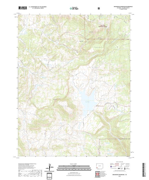
2022 Map of Groundhog Reservoir
USGS Topo · Published 2022About this map
Groundhog Reservoir serves as a central hydrological feature within this portion of the San Juan National Forest, where a complex system of water management is visible through numerous impoundments and irrigation works. The landscape is defined by its drainages and high-altitude terrain, including the steep descent of Hells Hole and the broad reach of Boggy Basin. Smaller bodies of water like Belmear Lake, Arrowhead Lake, and the Old Dunham Reservoir dot the northwestern sections, while the south is dominated by the North Nipple Reservoir and Saddle Reservoir Number Two. Human engineering is evident in the path of the Beaver Cr Ditch and the Little Fish Cr Ditch, which redirect natural flows across the varied elevations of Flattop Mtn and Island Mesa. Trail networks, such as the Lone Cone Trl and the Jim Olterman - Lone Cone Swa Trl, provide access to this high-country terrain.
Find a feature on this map
48 named features on this map. Tap any name to fly to it.
Don’t see what you’re looking for? This feature index may not catch every label — zoom into the map to look around manually.
Map Details
Editions of this 2022 Groundhog Reservoir Map
This is the sole edition of this map. No revisions or reprints were ever made.
Other maps of this area

1897 · Rico
USGS Topo · 1:62,500

1898 · Rico
USGS Topo · 1:62,500

1899 · Rico
USGS Topo · 1:62,500

1956 · Cortez
USGS Topo · 1:250,000

1958 · Cortez
USGS Topo · 1:250,000

1959 · Cortez
USGS Topo · 1:250,000

1962 · Cortez
USGS Topo · 1:250,000
1963 · Nipple Mountain
USGS Topo · 1:24,000
1963 · Clyde Lake
USGS Topo · 1:24,000
1964 · Groundhog Reservoir
USGS Topo · 1:24,000