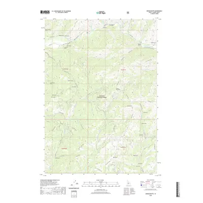
2020 Map of Grouse Butte
USGS Topo · Published 2020About this map
The Sawtooth National Forest dominates this section of Elmore County, where high peaks of the Soldier Mountains and the prominent Grouse Butte define the skyline. The northern reaches are carved by the South Fork Boise River, a major drainage fed by a complex network of gulches and creeks. Names like Log Chute Gulch and Schoolhouse Gulch suggest the area's history of early mountain industry and small-scale settlement.
Find a feature on this map
67 named features on this map. Tap any name to fly to it.
Don’t see what you’re looking for? This feature index may not catch every label — zoom into the map to look around manually.
Map Details
Editions of this 2020 Grouse Butte Map
This is the sole edition of this map. No revisions or reprints were ever made.
Other maps of this area

1892 · Camas Prairie
USGS Topo · 1:125,000

1893 · Camas Prairie
USGS Topo · 1:125,000

1894 · Rocky Bar
USGS Topo · 1:125,000

1955 · Hailey
USGS Topo · 1:250,000

1959 · Hailey
USGS Topo · 1:250,000

1962 · Hailey
USGS Topo · 1:250,000

1963 · Deer Mountain
USGS Topo · 1:24,000
1963 · Sprout Mtn
USGS Topo · 1:24,000
1964 · Featherville
USGS Topo · 1:24,000

1964 · Ross Peak
USGS Topo · 1:24,000