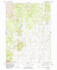
1991 Map of Grouse Creek
USGS Topo · Published 1991About this map
Grouse Creek anchors the eastern edge of this high-desert basin, where the Grouse Valley meets the foothills of the western mountains. The settlement is centered around a collection of local infrastructure including a Rodeo Ground, post office, and school, while the surrounding landscape is defined by its precarious water management. The irrigation network is highly visible, featuring the Etna Reservoir and its associated dam, which capture the waters of Straight Fork Creek and Etna Creek for the ranching operations below.
Find a feature on this map
37 named features on this map. Tap any name to fly to it.
Don’t see what you’re looking for? This feature index may not catch every label — zoom into the map to look around manually.
Map Details
Editions of this 1991 Grouse Creek Map
This is the sole edition of this map. No revisions or reprints were ever made.
Other maps of this area

1954 · Brigham City
USGS Topo · 1:250,000

1955 · Wells
USGS Topo · 1:250,000

1958 · Wells
USGS Topo · 1:250,000

1958 · Brigham City
USGS Topo · 1:250,000

1959 · Cotton Thomas Basin
USGS Topo · 1:62,500

1961 · Wells
USGS Topo · 1:250,000

1961 · Goose Creek
USGS Topo · 1:62,500

1961 · Dairy Valley
USGS Topo · 1:62,500

1962 · Brigham City
USGS Topo · 1:250,000
1971 · Toms Cabin Spring
USGS Topo · 1:24,000