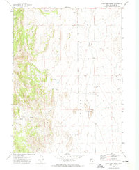
1971 Map of Toms Cabin Spring
USGS Topo · Published 1974About this map
Grouse Creek Valley defines this portion of Box Elder County, where the high desert floor meets a series of dramatic mountain slopes. The landscape is primarily defined by its hydrology and livestock history, centered on the reliable water found at Toms Cabin Spring and the flow of Toms Cabin Creek. Unlike the more developed regions of the state, this area remained largely a working rangeland in the early 1970s, evidenced by the presence of a lone Corral and a scattered network of Jeep Trails used by ranchers and prospectors. Natural landmarks like The Buttes provide vertical orientation within the valley, while watercourses such as Dairy Valley Creek, Etna Creek, and Grouse Creek indicate the seasonal drainage patterns crucial to this arid environment. A single Prospect and various gravel pits suggest small-scale mineral interests in an otherwise quiet, agricultural territory.
Find a feature on this map
16 named features on this map. Tap any name to fly to it.
Don’t see what you’re looking for? This feature index may not catch every label — zoom into the map to look around manually.
Map Details
Editions of this 1971 Toms Cabin Spring Map
2 editions found
Other maps of this area

1954 · Brigham City
USGS Topo · 1:250,000

1955 · Wells
USGS Topo · 1:250,000

1958 · Wells
USGS Topo · 1:250,000

1958 · Brigham City
USGS Topo · 1:250,000

1961 · Wells
USGS Topo · 1:250,000

1961 · Dairy Valley
USGS Topo · 1:62,500

1962 · Brigham City
USGS Topo · 1:250,000

1967 · Jackson Spring
USGS Topo · 1:24,000
1967 · Lucin NW
USGS Topo · 1:24,000

1967 · Lucin NE
USGS Topo · 1:24,000