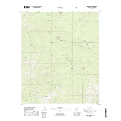
2020 Map of Grouse Mountain
USGS Topo · Published 2020About this map
Gila National Forest encompasses the entirety of this high-elevation landscape in the Mogollon Mountains. The terrain is defined by extreme relief, stretching from the crest of Whitewater Baldy down through deep drainages like Whitetail Canyon and Mogollon Canyon. Access to this backcountry is highlighted by Bursum Rd in the north and a network of historic routes including the Holt-Apache Trail and the Golden Link. The drainage patterns are intricate, with several forks of Whitewater Cr and W Fork Mogollon Cr carving out the steep topography. Named high points such as Willow Mtn, Sacaton Mtn, and Indian Peak provide a clear view of the complex ridgelines and saddles, including Simmons Saddle and Hummingbird Saddle, which historically served as vital points of passage for travelers and forestry workers alike.
Find a feature on this map
67 named features on this map. Tap any name to fly to it.
Don’t see what you’re looking for? This feature index may not catch every label — zoom into the map to look around manually.
Map Details
Editions of this 2020 Grouse Mountain Map
This is the sole edition of this map. No revisions or reprints were ever made.
Other maps of this area

1910 · Mogollon
USGS Topo · 1:125,000

1912 · Mogollon
USGS Topo · 1:125,000

1954 · Clifton
USGS Topo · 1:250,000

1957 · Clifton
USGS Topo · 1:250,000

1958 · Clifton
USGS Topo · 1:250,000

1962 · Clifton
USGS Topo · 1:250,000

1963 · Bearwallow Mountain
USGS Topo · 1:24,000

1963 · Negrito Mountain
USGS Topo · 1:24,000
1963 · Mogollon
USGS Topo · 1:24,000
1965 · Rice Ranch
USGS Topo · 1:24,000