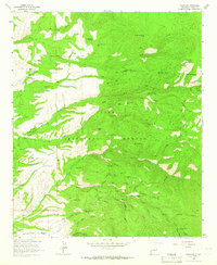
1963 Map of Mogollon
USGS Topo · Published 1965About this map
Mogollon sits at the heart of a dense mining district within the Gila National Forest, where the complex topography of Fannie Hill and Graveyard Gulch is marked by decades of subterranean industry. This 1963 field-checked survey documents a landscape transformed by the pursuit of silver and gold, evidenced by the numerous operations lining the canyons, including the Confidence Mine, Maud S Mine, and the Last Chance Mine. The concentration of sites around Mineral Creek and Silver Creek speaks to the intensive extraction era that defined this region of Catron County.
Find a feature on this map
198 named features on this map. Tap any name to fly to it.
Don’t see what you’re looking for? This feature index may not catch every label — zoom into the map to look around manually.
Map Details
Editions of this 1963 Mogollon Map
2 editions found
Other maps of this area

1910 · Mogollon
USGS Topo · 1:125,000

1912 · Mogollon
USGS Topo · 1:125,000

1915 · Reserve
USGS Topo · 1:125,000

1918 · Reserve
USGS Topo · 1:125,000

1954 · Clifton
USGS Topo · 1:250,000

1957 · Clifton
USGS Topo · 1:250,000

1958 · Clifton
USGS Topo · 1:250,000

1962 · Clifton
USGS Topo · 1:250,000

1963 · Bearwallow Mountain
USGS Topo · 1:24,000
1963 · Sign Camp Mountain
USGS Topo · 1:24,000