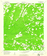
1958 Map of Groveland
USGS Topo · Published 1961About this map
The Seaboard Air Line railroad forms the industrial spine of this South Georgia landscape, connecting the small rail settlements of Groveland, Southward, and Reka as it pushes toward Pembroke. The terrain is defined by the dense, marshy lowlands of Bryan Bay and Bulloch Bay, which influenced the placement of early road networks and community centers. Long-established rural congregations are well-represented across the countryside, including Jerusalem Ch, Beautiful Zion Ch, and Mt Moriah Ch. These churches, often accompanied by burial grounds like the Beautiful Zion Cem, served as the primary social anchors for the dispersed farming families in Bulloch and Bryan Counties. An Old Railroad Grade north of Statesborough indicates an earlier generation of logging or freight transport that predated the late 1950s infrastructure shown here.
Find a feature on this map
24 named features on this map. Tap any name to fly to it.
Don’t see what you’re looking for? This feature index may not catch every label — zoom into the map to look around manually.
Map Details
Editions of this 1958 Groveland Map
This is the sole edition of this map. No revisions or reprints were ever made.
Other maps of this area

1919 · Claxton
USGS Topo · 1:62,500

1920 · Pembroke
USGS Topo · 1:62,500

1920 · Statesboro
USGS Topo · 1:62,500

1921 · Brooklet
USGS Topo · 1:62,500

1943 · Brooklet
USGS Topo · 1:62,500

1943 · Statesboro
USGS Topo · 1:62,500

1944 · Claxton
USGS Topo · 1:62,500

1947 · Savannah
USGS Topo · 1:250,000

1948 · Savannah
USGS Topo · 1:250,000

1948 · Pembroke
USGS Topo · 1:62,500