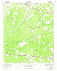
1976 Map of Groveland
USGS Topo · Published 1977About this map
The Seaboard Coast Line railroad dictates the southern settlement corridor of this Southeast Georgia landscape, connecting the communities of Groveland, Southward, Reka, and the city of Pembroke. This 1976 revision of earlier surveys highlights a rural economy transitioning from its heavy rail-dependent roots, as evidenced by an Old Railroad Grade cutting diagonally through the center of the sheet towards Mitchell Forks.
Find a feature on this map
24 named features on this map. Tap any name to fly to it.
Don’t see what you’re looking for? This feature index may not catch every label — zoom into the map to look around manually.
Map Details
Editions of this 1976 Groveland Map
This is the sole edition of this map. No revisions or reprints were ever made.
Other maps of this area

1919 · Claxton
USGS Topo · 1:62,500

1920 · Pembroke
USGS Topo · 1:62,500

1920 · Statesboro
USGS Topo · 1:62,500

1921 · Brooklet
USGS Topo · 1:62,500

1943 · Brooklet
USGS Topo · 1:62,500

1943 · Statesboro
USGS Topo · 1:62,500

1944 · Claxton
USGS Topo · 1:62,500

1947 · Savannah
USGS Topo · 1:250,000

1948 · Savannah
USGS Topo · 1:250,000

1948 · Pembroke
USGS Topo · 1:62,500