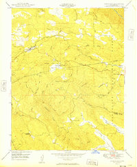
1949 Map of Groveland
USGS Topo · Published 1949About this map
The mountain town of Groveland serves as the hub for this 1940s survey of Tuolumne County, where the infrastructure of the Hetch Hetchy Aqueduct cuts a path across the landscape toward Kassabaum Meadow. The map documents a blend of California’s literary and industrial heritage, noting the Bret Harte Cabin near Second Garrotte and the scattered Ruins of earlier habitations. This area of the Stanislaus National Forest is deeply etched by mining history, evidenced by the Kanaka Mine to the north and the Red Jacket Mine near the western boundary.
Find a feature on this map
77 named features on this map. Tap any name to fly to it.
Don’t see what you’re looking for? This feature index may not catch every label — zoom into the map to look around manually.
Map Details
Editions of this 1949 Groveland Map
This is the sole edition of this map. No revisions or reprints were ever made.
Other maps of this area

1893 · Sonora
USGS Topo · 1:125,000

1896 · Sonora
USGS Topo · 1:125,000

1897 · Sonora
USGS Topo · 1:125,000

1898 · Sonora
USGS Topo · 1:125,000

1944 · Merced Falls
USGS Topo · 1:62,500

1947 · San Jose
USGS Topo · 1:250,000

1947 · Coulterville
USGS Topo · 1:62,500
1947 · Jawbone Ridge
USGS Topo · 1:24,000
1947 · Buckhorn Peak
USGS Topo · 1:24,000
1947 · Groveland
USGS Topo · 1:24,000