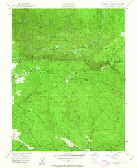
1947 Map of Jawbone Ridge
USGS Topo · Published 1963About this map
Stanislaus National Forest landscape dominates this mid-century survey, revealing a network of infrastructure and resource extraction near the Tuolumne-Mariposa county line. The Hetch Hetchy Aqueduct cuts through the subsurface of Jawbone Ridge, a critical piece of water engineering linking the Sierra Nevada to distant urban centers. Near the small settlement of Buck Meadows, the Groveland Ranger Station and Lost Claim Camp Ground highlight the area's role in forest management and early automobile-era tourism.
Find a feature on this map
46 named features on this map. Tap any name to fly to it.
Don’t see what you’re looking for? This feature index may not catch every label — zoom into the map to look around manually.
Map Details
Editions of this 1947 Jawbone Ridge Map
3 editions found

Other maps of this area

1893 · Sonora
USGS Topo · 1:125,000

1896 · Sonora
USGS Topo · 1:125,000

1897 · Sonora
USGS Topo · 1:125,000

1897 · Yosemite
USGS Topo · 1:125,000

1898 · Sonora
USGS Topo · 1:125,000

1900 · Yosemite
USGS Topo · 1:125,000

1903 · Yosemite
USGS Topo · 1:125,000

1909 · Yosemite
USGS Topo · 1:125,000

1947 · San Jose
USGS Topo · 1:250,000

1947 · Mariposa
USGS Topo · 1:250,000